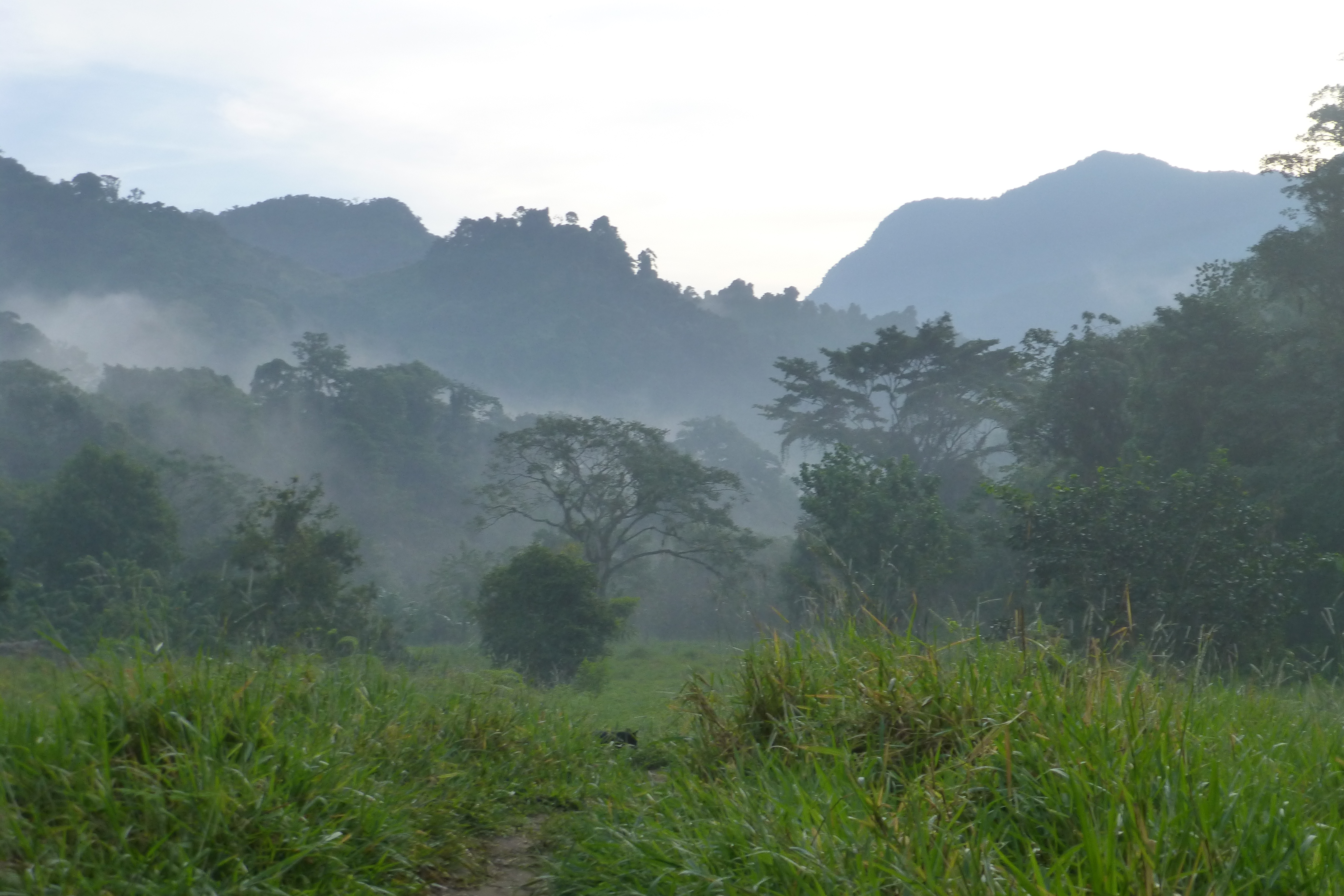
The Lost City, or Ciudad Perdida, is an ancient city in the Sierra Nevadas that is believed to have been built 650 years before Machu Picchu (around 800 CE) by the Tairona, the ancient ancestors of the area’s current tribes: the Kogis, the Wiwa, and the Arhuacas. It was “found” again in 1972 when treasure hunters discovered the 1200 stone steps that lead to the archaeological site. The trek to the Lost City is billed as “South America’s Greatest Trek,” but one must take that with a grain of salt since every country seems a bit loose with their superlatives. Suffice it to say that it’s a highly strenuous 44 km (23 miles) out-and-back hike spread over four days (you can do up to six, but we opted for the four-day)—all in lush, gorgeous jungle full of unique sounds, insects, flora, fauna, and the occasional Kogi village. Of course, there’s a trade-off: you can’t get this kind of beauty without payment in kind, which comes in the form of a tremendous amount of effort and discomfort. This trek does not disappoint for those in search of adventure.
Without further ado, let’s start the journey…
Day 1: El Mamey to Camp 1
Distance: Approx 7.6 km; 4 hours
We start off the trek in El Mamey and begin our hike to the first camp. It’s a supremely hot and humid day and immediately I begin lagging behind the other hikers. I’ve done a few treks in the past, but it suddenly occurs to me that I’ve never trekked in intense heat or humidity. I’m not someone who loves excessive heat—I begin wilting at 80 degrees. When you throw in humidity, I’m good for very little except lounging in an air-conditioned room with an iced coffee. Why hadn’t I considered all this before booking this trek?
Within a mere hour, I’m panicking. We’re on our first ascent and it’s both steep and in direct sunlight. My brain feels like it’s boiling inside my skull and my heart is racing. Soon, I notice everything I gaze upon is flickering. I realize that I might be nearing a heat stroke and start wondering what would happen if I died here. I ask the guide whether I should really be on this hike. Should I turn back? He insists that lots of people have difficulty with this stretch of the hike and encourages me to have some water and a rest, then continue. I do as he says and am able to stumble to the first checkpoint where I down some Gatorade. I typically hate Gatorade and all sports drinks, but this one tastes like liquid heaven.
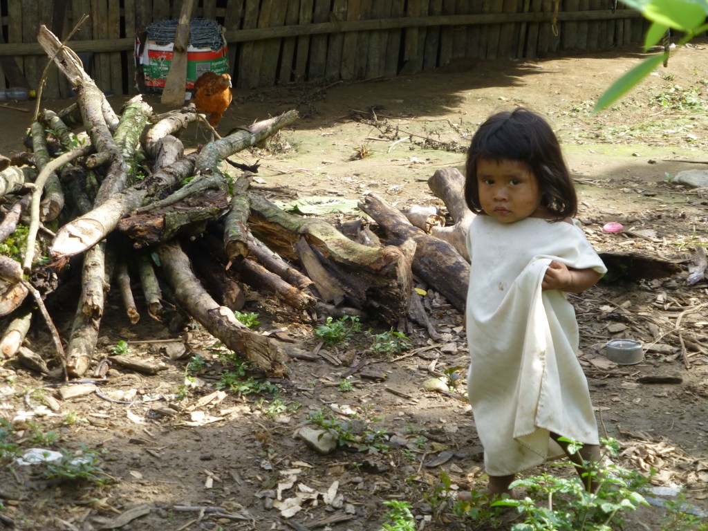
After the Gatorade, I feel like a new person and continue on happily, noting how green and lush the jungle is, how teeming with life. Leaf cutter ants busily carry their leaves in long lines across the path (David seems particularly interested in this activity, wondering why they don’t just move closer to the leaves so they don’t have to go so far), green lizards with iridescent stripes scurry away, and butterflies of all kinds flutter ahead, enticing you further into the jungle. A multitude of birds sing their tunes, some of which have peculiar lower tones that sound more like a human whistling. The occasional wild pig makes a timid appearance. Most everything in the jungle is brought in by donkeys, so donkeys pass by with loads strapped to their backs. One nearly knocks me over.
It begins to rain. This is the rainy season, so mornings are hot and sunny, with rain in the afternoons. Thankfully, this particular storm is brief and not too hard. Regardless, the rain has turned some of the trail into stretches of thick, heavy red mud that is nearly impossible to hike in, but we somehow manage to do it with a huge amount of exhausting effort.
We finally reach our first camp. The camps are more rustic than I’ve experienced on treks in the past (and those were pretty rustic). They are simple, wooden open-air structures with corrugated tin roofs and dirt floors. Under the roof are hammocks, mosquito nets, and bunks with bedding that was maybe washed in the last decade. Our guide tells us that the camps were once used as narco labs, but have since been converted to camps to support trekkers (apparently through a government-sponsored program). He says that the owners of these camps are happy to be making a living off of something other than cocaine. It’s a far more peaceful life.
Day 2: Trek to camp 2
Distance: Approx 12.7 km; 6-7 hrs
There’s nothing quite like putting on a wet bra in the morning. We washed our clothes after yesterday’s hike and hung them to dry, but this is the jungle and nothing really dries unless it’s in the hot afternoon sun. Our clothes are actually wetter than when we hung them, having soaked up extra moisture from the humid air. So much for “quick dry” technical clothing.

When we shuffle into the eating area to have breakfast, we discover that our group’s donkeys—the ones carrying our food—were hit by lightning during the night and are now dead. We think our guide is joking, but he isn’t. He’s busy distributing our group’s food load amongst the cook, other guides, and himself. David offers to carry something and gets some very aromatic onions. Now I can always tell if he’s nearby.
The first part of today’s hike isn’t too bad, but the second half is grueling with steep uphill climbs and downhills that you can’t really enjoy because the difficult terrain forces you to gingerly pick your way down. Many parts of the trail don’t look like a trail at all—it’s sometimes a trail, sometimes a muddy shoe-sucking bog, sometimes a stream, sometimes a small waterfall (that you have to climb), and sometimes a massive pile of downed trees that you have to scale, courtesy of hurricane Matthew, which made an appearance a few weeks ago. It’s because of the sheer number of various obstacles that I start imagining that David and I are characters in a video game (Super Chico and Super Chica!), crossing barriers and overcoming obstacles to get to the infamous Lost City…and earn prizes of tropical fruit on the way.
A storm moves in, complete with loud cracks of thunder and lightning. In the jungle, the thunder sounds like it’s all around you, getting ready to stomp you like the tiny bug that you are—and stomp it does: heavy raindrops begin to fall, making the hike more difficult due to the mud. We can’t wait out the storm because we need to reach the river before it gets too high. There are a few bridges on this trek, but interestingly none are over the major river crossings. That means we must cross on foot holding a fixed rope to keep from getting swept away in the fast current. We pick up our pace and finally get to the river. At this point, we are completely soaked so there’s no use in removing our shoes and socks. The river is up to my waist and tries to pull me hard in the direction of the current.
After the river crossing, we get to a bridge that was a casualty to hurricane Matthew. It hangs precariously from the side of a rock face, dangling down into the jungle abyss with only one lateral side exposed. Good god, we have to cross this thing. I’m by myself at this point (Super Chico is about 5 minutes behind me) and not sure what to do; however, there’s no one milling about here, so clearly they were able to cross. I gingerly test how secure it is, grab onto the rock that it’s attached to, and then slowly make my way across. (Broken bridge crossing: +10,000 points!). We finally make it to camp absolutely drenched. It’s another wet night for us.
Day 3: Camp 2 to Ciudad Perdida, then to Camp 3
Distance: Approx 13 km; 4 hours
Today is the big day. We get up at 5am and don our wet clothing so we can have breakfast and embark upon our hike to the Lost City, which is a short distance from the camp.
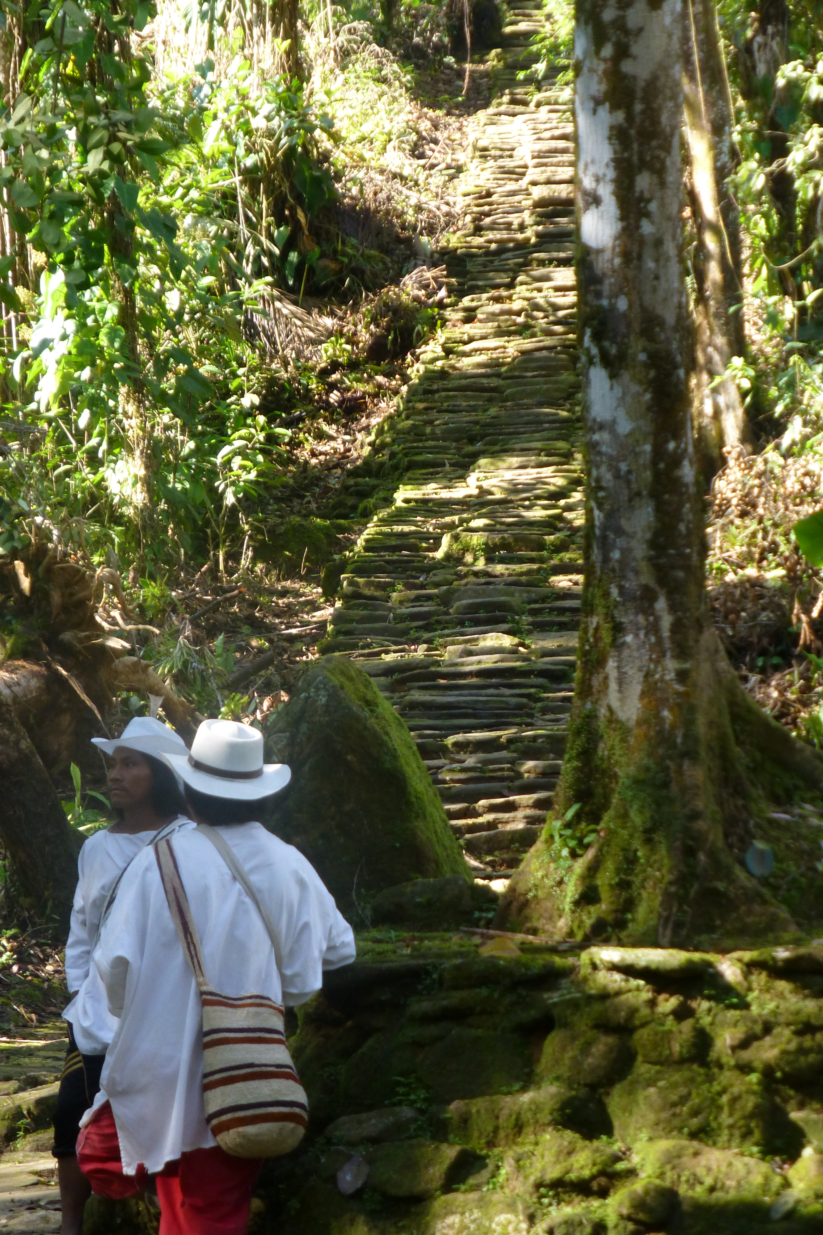
On our way there, we have yet another river crossing. I optimistically roll up my pants, but the river is up to my bum today, so it was a useless gesture. Shortly after leaving the river, we come upon the 1200 stone steps that lead up to Ciudad Perdida. They are shaded by the trees, so the steep steps are slick—and in some spots, so steep that it feels like climbing a ladder. I begin the slow process of climbing up. I feel like I’m about to approach the grand prize—the whole object of this crazy survivor game—while David notes that it really should be 1198 steps since two are missing, forcing us to find a way around them. Ah, Super Chico.

Finally, we reach the entrance to the Lost City. (Reach the Lost City: a million bonus points!). There are many downed trees here, once again because of the recent hurricane. Regardless, it’s beautifully green and lush, with many meticulously laid concentric stones. Our guide tells us that these stones mark where a home once stood. We’re told that the Tairona had to bless every stone used in the Lost City twice in order to properly thank the earth for its offering; as a result, the city took approximately 200 years to build. Some stones are absolutely massive. The Taironas painstakingly moved these stones by rolling them on wood. No crazy pyramid theories here.
We still have a trek ahead of us, so after a few hours of exploring the Lost City, we begin to head back, very carefully, on those wet stone steps. The effort of concentrating so hard on not slipping has me dripping with sweat. After crossing the river (again, I rolled up my pants. Why do I bother?), we hike to camp 3. A storm hits—the hardest since we got here—and we slip and slide our way into camp. I’m in a particularly cranky mood from being soaked and slipping in the mud repeatedly. (Bad attitude: -5000 points for Super Chica. Womp womp.)
Day 4: Camp 3 to El Mamey
Distance: Approx 13.6 km; supposed to be 7 hrs, but for me it’s more like 7:40
Today is the last day of the hike and also the longest and toughest with two difficult uphill climbs in the hottest part of the day. Knowing that I tend to be slower on uphills, I ask the guide if I can leave early to get a head start and he agrees. I figured: the trail doesn’t vary that often and I didn’t recall any forks when we came this way before, so why not? I head off on my own and about an hour into the hike, pass the Wiwa camp (another campsite). I continue straight on the trail and soon find myself at the river with massive boulders along it. So far, this trail has had every possible terrain you can imagine: climbing rocks, climbing a small waterfall, crossing waist-high rivers, gingerly stepping along a broken and dangling bridge—huge boulders are just par for the course. True, I don’t recall this part of the trail, but I’m bone-tired and not recalling much, so I power ahead. The boulders are extremely slippery, so I find myself clambering over them, sliding and pulling myself along until I realize it’s much harder than I remember…not to mention extremely dangerous with all the slipperiness. I finally look down on a patch of sand to see where the trail starts again and realize there is no logical way forward, and more importantly: there are no footprints there. No one has come this way. Oh snaaap. I already slid down a really large, slippery boulder to get to this spot and now I need to find a way to scale it to go back. I have a moment of panic and wonder if I should just stay put and yell for help, but decide to give it a go before I resort to that. After much effort and creativity, I heave my way up and over the boulder and then slip and slide over the remaining boulders to get back to the trail and do some backtracking. I return to the Wiwa camp and realize there was another trail that I didn’t see on the left of the camp, and that one has footprints. At least 40 minutes have passed since my wrong turn, so now I am behind my group and they don’t know it. I realize I’m going to need to speed up my pace. (Take the wrong path: -20,000 points for Super Chica. Womp womp.)
I hike as quickly as I can to catch up to the group, hoping that they weren’t worried when they didn’t see me at the first checkpoint. After a few hours of hiking by myself, I catch up to them at the site of our first morning fruit break (I wasn’t kidding about the fruit prizes). I arrived just five minutes after they did, so I made amazing time, but I paid for it in energy. I was utterly exhausted from both my extra adventure and my effort to catch up—and the longest and hottest part of the day was still ahead of me.
After the break, we commence our trek—back over rock, mud bog, tree fall, and stream. I’m so exhausted that I barely recognize the trail, even though it’s the same one we took before. The sun is beating down, I’m still wet from sweat and stream crossings, and my shoes are caked in mud. Super Chico is still as chatty as ever, noting the lizards and butterflies, but my little side adventure took all of my last strength and I fail to appreciate these things properly. At this point, I think Super Chico should be awarded extra points for being this far into the trek and still appreciating his surroundings. +10,000 bonus points for Super Chico.
Finally, we make it to El Mamey, the town where we first began. We’re sweaty, sore, bug-bitten, and to say we’re “exhausted” doesn’t quite cover it. We also stink. This was hands-down the hardest trek I’ve ever done, but mostly due to the difficult trail conditions and the extreme weather. I can hardly believe we did it, but I am too tired to appreciate our triumph. I just want a shower.
Super Chico and Super Chica win the game.
Notes for future trekkers:
Difficulty: High difficulty. I’ve read that this trek is considered of “medium-high difficulty,” but that wasn’t the case on our trek, perhaps due to weather conditions or the havoc that the recent hurricane wrought upon the trail. Best to plan for high difficulty, then be pleasantly surprised if yours isn’t.
Fitness: You should be fairly fit for this trek.
Packing: You have to carry your own pack, so keep it light. This is what we brought:
- One change of clothes to hike in (you can wash these each night)
- One change of clothes to change into after the day’s hike
- Bathing suit (for quick dips in the river)
- Underwear and socks for each day
- Quick-dry hat
- Quick-dry travel towel
- First-aid (e.g., moleskin or blister care)
- Bug spray (recommend at least 30% DEET)
- Sunblock
- Camelback for water
- Headlamp
- Toilet paper (guide companies say you don’t need to bring this, but that wasn’t the case for our trek)
- Extra plastic bags to keep stuff dry, or to separate your wet things
- Minimum toiletries, including a small bottle of detergent for washing or a multi-purpose eco soap)
- Earplugs (for the communal sleeping arrangements)
- Trekking poles (I’ve read you can just pick up a walking stick from someone finishing the hike, but never actually saw that happen. Highly recommend you bring your own. Mine saved my tookus a few times when the going got rough.)
- Proper hiking shoes (don’t even get me started on this as I brought the wrong shoes based on a forum post I read before the trek. If you’re going during rainy season, I recommend hiking boots with ankle support; in the dry season, you could probably get away with something lighter).
- Flip-flops or other water shoe that you can also use in the shower
- Sleep sack (highly recommended)
Happy trekking!


Leave a comment